
Last Updated on October 14, 2023
In this post, a look at city wayfinding in Cardiff, Wales.
Cardiff, Wales, is a city that offers the liveliness of a capital city which is relatively compact as an urban centre.
For visitors, the city centre and its urban area provide a number of attractions which are all within walking distance of each other such as Cardiff Castle, the Millennium Stadium, St David’s Shopping Centre and within a short hop on the train to Cardiff Bay.
Everything is within a short walk or cheap taxi ride from the centre and this certainly makes Cardiff a good location for a visit.
The centre tends to be popular with the so-called ‘Mystery Coach Tours‘ (trips where the location is unknown and marketed this way) from cities such as Plymouth and other towns and cities within a 2 – 3 hours drive and given the range of attractions and shopping in the centre, it is understandable why.

One of the great wonders of the city that you might not immediately be aware of when visiting the city is the Taff Trail.
The trail offers you the chance to cycle from Cardiff Bay all the way to the Brecon Beacons, a route of over 50 miles and which is relatively easy to navigate (at least if you print a map of the route). City wayfinding at its best.

Next to the city centre, Bute Park is a very popular area (the Taff Trail runs through it) and which offers a link by water taxi with Cardiff Bay and the city centre.
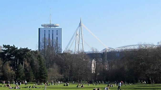
The park itself is easy to navigate given that from many points in the park you have a skyline view of the Millennium Stadium.
The stadium and castle act as perfect guidance points for always having an idea of the direction of the centre.
The park is also well signposted and thus worth exploring if you want to enjoy the outdoors when in the centre.
Table of Contents
City Wayfinding and Centre Layout
The centre of Cardiff has contours both natural and man-made which nicely encapsulate the area, making it easy for tourists and other visitors to navigate the centre without really ever getting lost.
The west of the centre is bordered by the Taff River and marked out by the Millennium Stadium.
The Northside is bordered by Bute Park and the castle, whilst the rail tracks mark the centre’s borders out on the eastern and southern sides.
The centre of Cardiff is simply quite small when compared to a city such as London or NYC and navigation for those looking to explore the centre is relatively easy.
The urban centre of the city is ideally suited for recreational wayfinding.

Electronic Wayfinding Maps
There is an attempt at providing wayfinding help in the St David’s Shopping centre in the centre, with the technology used in the form of touch maps.
One wonders though if these maps are created using guesswork and how much effort is given into planning and creating such a map.
In an era where we have video technology, one wonders why we still need Atari style the 1970s and 1980s-style graphics when we have the technology to create actual video maps.
My experience of using the map to try and find the Nando’s in the mall (we love Nando’s – the BBQ chicken, Greek salad and corn on the cob is enough to fill the stomach of any hungry navigator) but on using the map and taking what we understood to be the correct directions from using the touch map, we ended up clearly misunderstanding the directions or perhaps being given the wrong directions as we, as it turned up, walked in the opposite direction to what we needed.
Guesswork would have been as effective as the touch map, at least from our own personal experience.
I am good with directions normally and feel I have a good sense of direction and so the touch map for me just did not work.

It is great to see planners trying to use technology but we seem to have a long way to go with the basic touch maps in St David’s shopping centre.
A simple visual map would have been much more effective, can be used by more than one person at a time and avoids the frustration of clicking away on a screen.
It made things more frustrating rather than helpful using the touch map.

Cardiff Bay
Probably the one surprising aspect of city planning in the centre of the city is the lack of walking route between the city centre and Cardiff Bay.
There are roads such as the A470 and the Central Link roads which both provide pavements which can be used to navigate between the bay and the centre.
Neither though have been developed in a way which really makes for a pleasurable walk which really attracts tourists.
Such an area has incredible potential and for use for example as a market street and area akin to Las Ramblas in Barcelona, Spain.
Cardiff Bay has undergone quite incredible transformation over the last 15 years and perhaps the area connecting the centre and the bay will eventually be connected.
For those who love to walk and cycle and shop, such an area is the obvious next step and one which will make navigating between the two locations even more pleasurable.
Walking around the centre
One of the great things about Cardiff centre is the pedestrianisation of a few of the main streets and you might agree that navigating around travel space without the worry of vehicles makes the experience that much easier and more relaxing.
The compactness of the centre makes wayfinding straightforward in many respects although having to deal with signs in two languages (see placement section on design basics) can add to the confusion.
Few foreign tourists will speak Welsh and might not even be comfortable in English but are able to understand signs in English.
One of the basics of signage design is to design for the users and not for the politicians and this is perhaps a contentious issue in a city such as Cardiff which one suspects, local government and service providers would love to see more tourists from outside of Wales visit.
The desire to protect a local language versus signage that is usable for tourists is one I will leave for others to debate.
One could say though that the use of the Welsh language, although it does not make wayfinding easier (but if anything more complicated for the majority of visitors), does add an ‘exotic’ dimension.
For example, for those Italians who have been to Wales, one of the things they might remember is seeing signs written in this strange (for them) language where words have a lot of consonants.
The composition and existence of the language that is only understood in Wales, can add a dimension of cultural interest and curiosity for the tourist who travels to Wales.
It is not enough of a reason for people to want to travel to Wales and it cannot be justified if wayfinding is considered a priority, but it does perhaps add a bit of extra flavour to a visitor’s experience.
These multi-language signs do perhaps add character though albeit resulting in signs which can be confusing and cluttered.
It is for local politicians to argue the case perhaps language and tourists’ needs.

In signage design, it can often be tempting to try and show extra creativity but standardisation of colour coding is always a good idea.
Try and avoid the temptation to use different coloured backgrounds and colours such as those shown in the image below with the ‘Church Street’ and ‘St Mary Street’ signs.
Aesthetically they do look nice but for the person trying to find their way, different coloured signs which represent the same sign type is never a good idea and ultimately leads to confusion unnecessarily.
The brown sign with gold lettering also is not perhaps the clearest option, particularly when viewed from a distance.

Dr Paul Symonds has a PhD in Wayfinding from Cardiff Metropolitan University in the UK. Paul works with the signage industry, airports and other locations providing wayfinding audits, consultancy and training.


